One of the most common ingest actions is to ingest layer-level geospatial XML metadata documents. ogpIngest currently supports ingest of FGDC and ISO 19115/19139 metadata, either as individual files or as zipped bundles.
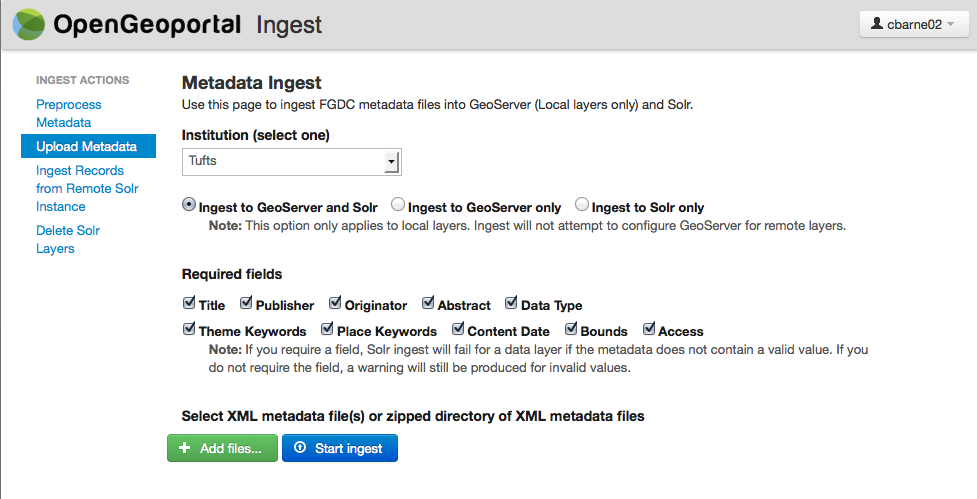
Selecting an Institution on the form does several things. Most obviously, it sets the value for the Institution field for the resulting documents in the OGP Solr index. This value is not readily discoverable from metadata documents, so it must be set manually. Setting this value also tells ogpIngest which values to read from the config file (ingest.properties), which may contain information such as the WorkspaceName, guidelines on how to parse layer names from the metadata, and default values for online Location.
If the selected Institution is ‘local’ (also set in ingest.properties), the user has the option to attempt to register the layer with a GeoServer instance. To accomplish this, ogpIngest will first parse a layer name from the metadata document (or the document’s file name, which is a common convention), then prefix the name with a qualifier, if set (if your geospatial data is stored in a DBMS, layer names may look something like “GISPORTAL.GISOWNER01.YOUR_LAYER_NAME”). Using the GeoServer REST API, ogpIngest will look for the layer in the GeoServer datastore specified in ingest.properties. Separate GeoServer datastores, at separate urls if desired, may be registered for ‘public’ and ‘restricted’ layers. If there is a match with your layer, a request is made to configure the layer in GeoServer if it has not already been configured. Processing stops on failure of this process so that layers without working web services are not searchable in OGP.
The Required fields selection allows the user to require which fields must be present, and where possible, “valid” for the metadata to be ingested into the Solr index. If a field is not “required” by the user, detected problems will be presented in the report as “Warnings”, rather than “Failures”, and the metadata will be ingested.